Bar nearby Freedom Bar
Finland
Bar nearby Freedom Bar
Freedom Bar
Mäntymäki 2, 00250 Helsinki, Finlandia
contacts phone
:
+358 44 7095912
website:
freedombar.fi
Latitude:
60.1836522
, Longitude:
24.9289367
larger map & directions
read more
nearest Bar
763 m
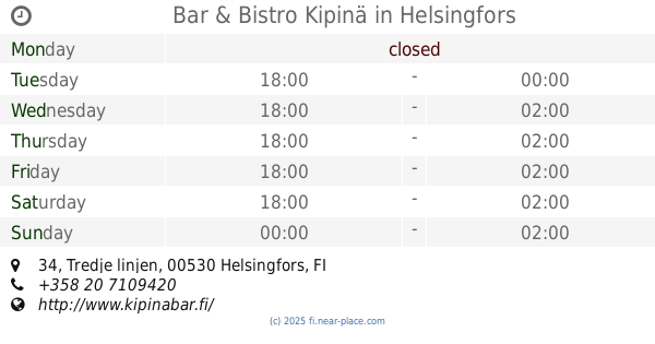
Bar & Bistro Kipinä
Tredje linjen 34, Helsingfors
Bar
read more
986 m
MEXI
Mannerheimintie 53, Helsinki
Bar
read more
1.013 km
Viisi Penniä
Mannerheimintie 55, Mäntyniemi
Bar
read more
1.025 km
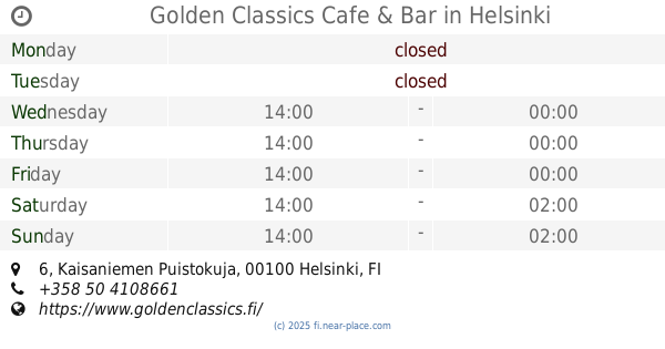
Golden Classics Cafe & Bar
Kaisaniemen Puistokuja 6, Helsinki
Bar
read more
1.263 km
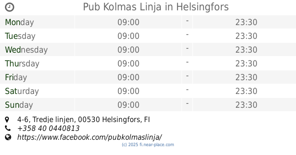
Pub Kolmas Linja
Tredje linjen 4-6, Helsingfors
Bar
read more
1.412 km
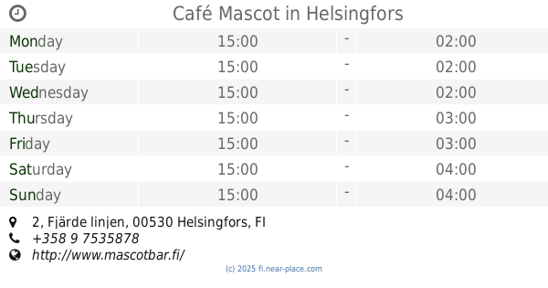
Café Mascot
Fjärde linjen 2, Helsingfors
Bar
read more
1.509 km
Hakis Pub Gazal
Sörnäisten rantatie 10, Helsinki
Bar
read more
1.521 km
Kuja Bar and Bistro
Hakaniemenkatu 7, Helsinki
Bar
read more
1.574 km
The Pullman Bar & Lounge
Finland
Bar
read more
1.574 km
The Pullman Bar & Lounge
Nervanderinkatu 5
Bar
read more
1.604 km
Bar Tappen
Kustaankatu 7, Helsinki
Bar
read more
1.685 km
Sports Academy Helsinki
Keskuskatu 6
Bar
read more
1.689 km
Bruuveri
Fredrikinkatu 63 AB, Helsinki
Bar
read more
1.704 km
Virgin Oil Co.
Mannerheimintie 5, Helsinki
Bar
read more
1.706 km
Old Hat
Mannerheimintie 3, Helsinki
Bar
read more
1.727 km
Kultapalmu
Vaasankatu 4, Helsinki
Bar
read more
1.803 km
Irish Pub
25 00100, Yrjönkatu 23
Bar
read more
1.833 km
Base Bar
Kalevankatu 3, Helsinki
Bar
read more
1.834 km
Café Cavalier
Malminrinne 2-4, Helsinki
Bar
read more
1.844 km
U. Kaleva
Kalevankatu 3 A, Helsinki
Bar
read more
1.877 km
Gaselli
Aleksanterinkatu 46, Helsinki
Bar
read more
1.931 km
Morris
Mäkelänkatu 30
Bar
read more
1.965 km
DTM
Mannerheimvägen 6b, Helsingfors
Bar
read more
2.127 km
Ravintola Rymy-Eetu
Erottajankatu 15, Helsinki
Bar
read more
2.336 km
Pub Westminster
Hämeentie 94, Helsinki
Bar
read more
📑
all categories
Accounting
Administrative area level 1
Administrative area level 2
Airport
Amusement park
Aquarium
Art gallery
Atm
Bakery
Bank
Bar
Beauty salon
Bicycle store
Book store
Bowling alley
Bus station
Cafe
Campground
Car dealer
Car rental
Car repair
Car wash
Casino
Cemetery
Church
City hall
Clothing store
Colloquial area
Convenience store
Courthouse
Dentist
Department store
Doctor
Electrician
Electronics store
Embassy
Establishment
Finance
Fire station
Florist
Food
Funeral home
Furniture store
Gas station
General contractor
Grocery or supermarket
Gym
Hair care
Hardware store
Health
Hindu Temple
Home goods store
Hospital
Insurance agency
Jewelry store
Laundry
Lawyer
Library
Light rail station
Liquor store
Local government office
Locality
Locksmith
Lodging
Meal delivery
Meal takeaway
Mosque
Movie rental
Movie theater
Moving company
Museum
Natural feature
Neighborhood
Night club
Painter
Park
Parking
Pet store
Pharmacy
Physiotherapist
Place of worship
Plumber
Point of interest
Police
Political
Post office
Premise
Real estate agency
Restaurant
Roofing contractor
Route
Rv park, camping
School
Shoe store
Shopping mall
Spa
Stadium
Storage
Store
Subpremise
Subway station
Supermarket
Synagogue
Taxi stand
Train station
Transit station
Travel agency
University
Veterinary care
Zoo
administrative area level 3
↑