Bar nearby Cafe Efes Bar
Finland
Bar nearby Cafe Efes Bar
Cafe Efes Bar
2, Helsinginkatu, 00500, Helsinki, FI Finland
contacts phone
:
+358
website:
m.facebook.com
Latitude:
60.1874585
, Longitude:
24.9608178
larger map & directions
read more
nearest Bar
76 m
Sivuraide
Hämeentie 54, Helsinki
Bar
read more
85 m
Kolme Kaisaa
Hämeentie 29, Helsinki
Bar
read more
103 m
Ravintola Iltakoulu
Vaasankatu 5, Helsinki
Bar
read more
124 m
Olutravintola Hilpeä Hauki
Vaasankatu 7, Helsinki
Bar
read more
144 m
Kultapalmu
Vaasankatu 4, Helsinki
Bar
read more
192 m
Solmu Pub
Vaasankatu 8, Helsinki
Bar
read more
219 m
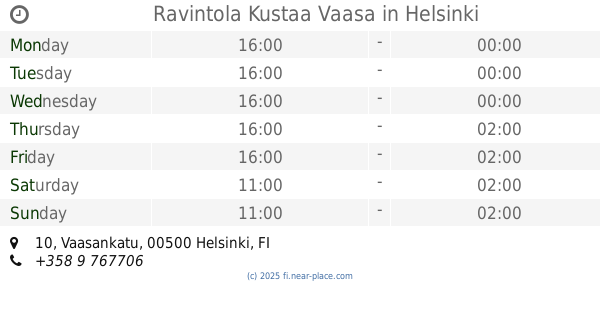
Ravintola Kustaa Vaasa
Vaasankatu 10, Helsinki
Bar
read more
254 m
Office Bar
Vilhelmsbergsgatan 7, Helsingfors
Bar
read more
291 m
Bar Tappen
Kustaankatu 7, Helsinki
Bar
read more
293 m
Sörkan Ruusu
Svalbobrinken 3, Helsingfors
Bar
read more
323 m
Ravintola Tenkka
Helsinginkatu 15
Bar
read more
437 m
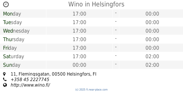
Wino
Flemingsgatan 11
Bar
read more
673 m
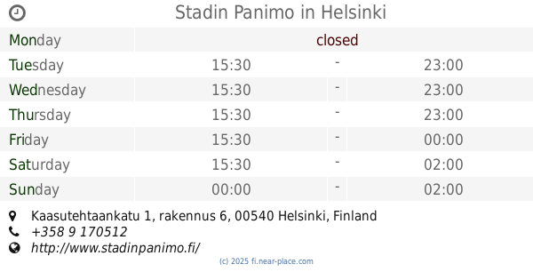
Stadin Panimobaari Oy
Kaasutehtaankatu 1, Helsinki
Bar
read more
683 m
Stadin Panimo
Kaasutehtaankatu 1, rakennus 6, Helsinki
Bar
read more
699 m
B-Side Bar
Teurastamo, Työpajankatu 2, Helsinki
Bar
read more
746 m
Mascot Bar & Live Stage
Fjärde linjen 2, Helsingfors
Bar
read more
749 m
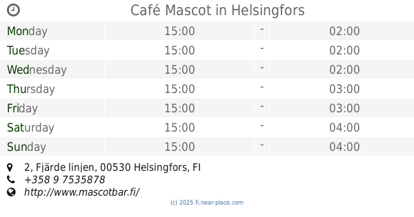
Café Mascot
Fjärde linjen 2, Helsingfors
Bar
read more
818 m
Morris
Mäkelänkatu 30
Bar
read more
821 m
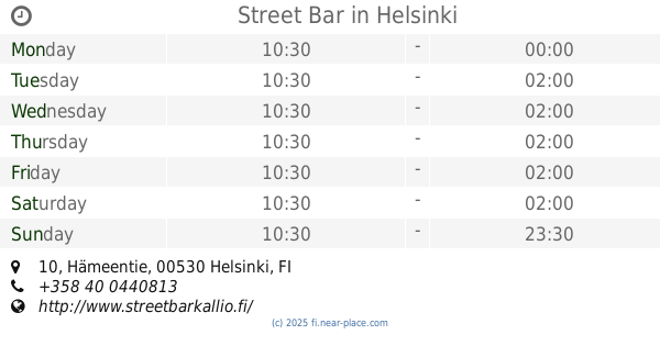
Street Bar
Hämeentie 10
Bar
read more
841 m
Don Alberto My Way
Mäkelänkatu 32, Helsinki
Bar
read more
842 m
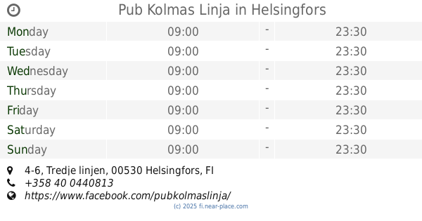
Pub Kolmas Linja
Tredje linjen 4-6, Helsingfors
Bar
read more
934 m
Hakis Pub Gazal
Sörnäisten rantatie 10, Helsinki
Bar
read more
1.002 km
Kuja Bar and Bistro
Hakaniemenkatu 7, Helsinki
Bar
read more
1.213 km
Scandic Paasi
Paasivuorigatan 5 B, Helsingfors
Bar
read more
2.246 km
Sports Academy Helsinki
Keskuskatu 6
Bar
read more
📑
all categories
Accounting
Administrative area level 1
Administrative area level 2
Airport
Amusement park
Aquarium
Art gallery
Atm
Bakery
Bank
Bar
Beauty salon
Bicycle store
Book store
Bowling alley
Bus station
Cafe
Campground
Car dealer
Car rental
Car repair
Car wash
Casino
Cemetery
Church
City hall
Clothing store
Colloquial area
Convenience store
Courthouse
Dentist
Department store
Doctor
Electrician
Electronics store
Embassy
Establishment
Finance
Fire station
Florist
Food
Funeral home
Furniture store
Gas station
General contractor
Grocery or supermarket
Gym
Hair care
Hardware store
Health
Hindu Temple
Home goods store
Hospital
Insurance agency
Jewelry store
Laundry
Lawyer
Library
Light rail station
Liquor store
Local government office
Locality
Locksmith
Lodging
Meal delivery
Meal takeaway
Mosque
Movie rental
Movie theater
Moving company
Museum
Natural feature
Neighborhood
Night club
Painter
Park
Parking
Pet store
Pharmacy
Physiotherapist
Place of worship
Plumber
Point of interest
Police
Political
Post office
Premise
Real estate agency
Restaurant
Roofing contractor
Route
Rv park, camping
School
Shoe store
Shopping mall
Spa
Stadium
Storage
Store
Subpremise
Subway station
Supermarket
Synagogue
Taxi stand
Train station
Transit station
Travel agency
University
Veterinary care
Zoo
administrative area level 3
↑