Bar nearby Elmun Baari
Finland
Bar nearby Elmun Baari
Elmun Baari
8, Telakkakatu, 00150, Helsinki, FI Finland
contacts phone
:
+358 9 42893006
website:
elmunbaari.fi
Latitude:
60.15965
, Longitude:
24.930797
larger map & directions
read more
nearest Bar
266 m
Ravintola Huvipursi
Pursimiehenkatu 27, Helsinki
Bar
read more
303 m
Hemingway's
Hietalahdenranta 11, Helsinki
Bar
read more
414 m
RO-RO Bar
Gräsvikskajen 3
Bar
read more
518 m
Apéro BarCafé
Kalevankatu 46, Helsinki
Bar
read more
547 m
Huutokonttori Kanttiini
Tyynenmerenkatu 1, Helsinki
Bar
read more
580 m
Pacific 7
Tyynenmerenkatu 7
Bar
read more
683 m
Sportacam
Kalevankatu 28, Helsinki
Bar
read more
683 m
Bar Mendocino
Eerikinkatu 28
Bar
read more
708 m
Bar Bronco Iso Roba
Iso Roobertinkatu 15, Helsinki
Bar
read more
748 m
Oluthuone Lehto
Annankatu 3, Helsinki
Bar
read more
762 m
Bar Paloma
Iso Roobertinkatu 14, Helsinki
Bar
read more
828 m
Leijuva Lahna
Eerikinkatu 14, Helsinki
Bar
read more
837 m
Café Cavalier
Malminrinne 2-4, Helsinki
Bar
read more
971 m
Ohrana Krouvi Panimo
Högbergsgatan 27, Helsingfors
Bar
read more
977 m
Amsterdam
Itämerenkuja 1 C, Helsinki
Bar
read more
977 m
Oluthuone Amsterdam
Itämerenkuja 1 c, Helsinki
Bar
read more
987 m
Bruuveri
Fredrikinkatu 63 AB, Helsinki
Bar
read more
987 m
Pub Notre Dam
Östersjögränden, Helsingfors
Bar
read more
1.013 km
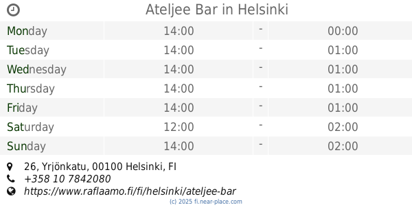
Ateljee Bar
Yrjönkatu 26, Helsinki
Bar
read more
1.028 km
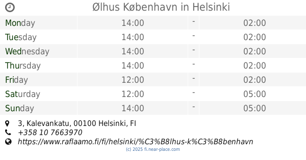
Ølhus København
Kalevankatu 3, Helsinki
Bar
read more
1.029 km
Ravintola Rymy-Eetu
Erottajankatu 15, Helsinki
Bar
read more
1.035 km
U. Kaleva
Kalevankatu 3 A, Helsinki
Bar
read more
1.037 km
Irish Pub
25 00100, Yrjönkatu 23
Bar
read more
1.042 km
DTM
Mannerheimvägen 6b, Helsingfors
Bar
read more
1.045 km
Base Bar
Kalevankatu 3, Helsinki
Bar
read more
📑
all categories
Accounting
Administrative area level 1
Administrative area level 2
Airport
Amusement park
Aquarium
Art gallery
Atm
Bakery
Bank
Bar
Beauty salon
Bicycle store
Book store
Bowling alley
Bus station
Cafe
Campground
Car dealer
Car rental
Car repair
Car wash
Casino
Cemetery
Church
City hall
Clothing store
Colloquial area
Convenience store
Courthouse
Dentist
Department store
Doctor
Electrician
Electronics store
Embassy
Establishment
Finance
Fire station
Florist
Food
Funeral home
Furniture store
Gas station
General contractor
Grocery or supermarket
Gym
Hair care
Hardware store
Health
Hindu Temple
Home goods store
Hospital
Insurance agency
Jewelry store
Laundry
Lawyer
Library
Light rail station
Liquor store
Local government office
Locality
Locksmith
Lodging
Meal delivery
Meal takeaway
Mosque
Movie rental
Movie theater
Moving company
Museum
Natural feature
Neighborhood
Night club
Painter
Park
Parking
Pet store
Pharmacy
Physiotherapist
Place of worship
Plumber
Point of interest
Police
Political
Post office
Premise
Real estate agency
Restaurant
Roofing contractor
Route
Rv park, camping
School
Shoe store
Shopping mall
Spa
Stadium
Storage
Store
Subpremise
Subway station
Supermarket
Synagogue
Taxi stand
Train station
Transit station
Travel agency
University
Veterinary care
Zoo
administrative area level 3
↑