Cafe nearby Kahvila P
Finland
Cafe nearby Kahvila P
Kahvila P
Museokatu 34 A 3, 00100 Helsinki, Finlandia
contacts phone
:
+358 40 8418118
website:
www.pikkurastas.net
Latitude:
60.175031
, Longitude:
24.9239989
larger map & directions
read more
nearest Cafe
29 m
Voffeli & Kaffeli
Museigatan 19
Cafe
read more
186 m
Cafe Foto
Museigatan 9, Helsingfors
Cafe
read more
216 m
Cafetoria Café & Shop
Runebergsgatan 31
Cafe
read more
227 m
Cafe & Eepos
Runebergsgatan 29
Cafe
read more
236 m
Marocco
Museigatan 7, Helsingfors
Cafe
read more
237 m
Riisi Café
Eteläinen Hesperiankatu 12
Cafe
read more
327 m
Hopia
Pohjoinen Hesperiankatu 9, Helsinki
Cafe
read more
376 m
Pähkinänsärkijä
Tölötorggatan 4b
Cafe
read more
394 m
Cafe Tin Tin Tango
Tölötorggatan 7, Helsingfors
Cafe
read more
513 m
Picnic Töölöntori
46, Runeberginkatu
Cafe
read more
550 m
Raw n' More
Runebergsgatan 59, Helsingfors
Cafe
read more
583 m
Kahvila Airo
Merikannontie 1, Helsinki
Cafe
read more
701 m
Kahvi Charlotta
Runebergsgatan 5b, Helsingfors
Cafe
read more
748 m
Lumière
Tennispalatsi, Salomonkatu 15, Helsinki
Cafe
read more
778 m
Ravintola Basti's
Alvar Aallon katu 3, Helsinki
Cafe
read more
798 m
Kiasma Café
Mannerheimplatsen 2, Helsingfors
Cafe
read more
829 m
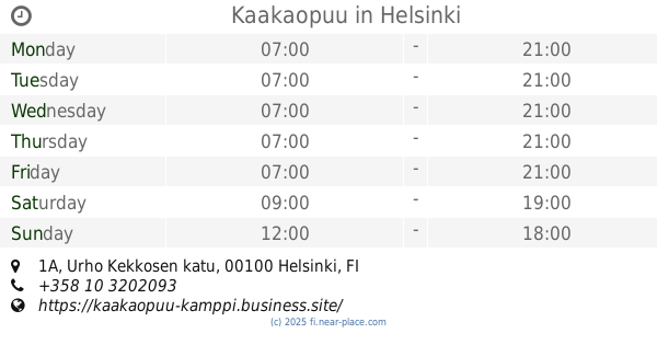
Kaakaopuu
Urho Kekkosen katu 1A, Helsinki
Cafe
read more
959 m
Sokos Café
Mannerheimintie 9, Helsinki
Cafe
read more
984 m
Isabella Cafe
Helsinki, 3 Elielinaukio
Cafe
read more
1000 m
Ciao! Caffé
Kauppakeskus Forum, 3. kerros, Mannerheimintie 20
Cafe
read more
1.014 km
Picnic Forum
Mannerheimintie 20, Helsinki
Cafe
read more
1.043 km
Robert's Coffee Rautatieasema
Kaivokatu 1
Cafe
read more
1.116 km
Jungle Juice Bar Asematunneli
Aleksanterinkatu 21, Helsinki
Cafe
read more
1.204 km
Robert's Coffee
Aleksanterinkatu 52 A, Helsinki
Cafe
read more
1.224 km
Kanniston Leipomo
Annankatu 20, Helsinki
Cafe
read more
📑
all categories
Accounting
Administrative area level 1
Administrative area level 2
Airport
Amusement park
Aquarium
Art gallery
Atm
Bakery
Bank
Bar
Beauty salon
Bicycle store
Book store
Bowling alley
Bus station
Cafe
Campground
Car dealer
Car rental
Car repair
Car wash
Casino
Cemetery
Church
City hall
Clothing store
Colloquial area
Convenience store
Courthouse
Dentist
Department store
Doctor
Electrician
Electronics store
Embassy
Establishment
Finance
Fire station
Florist
Food
Funeral home
Furniture store
Gas station
General contractor
Grocery or supermarket
Gym
Hair care
Hardware store
Health
Hindu Temple
Home goods store
Hospital
Insurance agency
Jewelry store
Laundry
Lawyer
Library
Light rail station
Liquor store
Local government office
Locality
Locksmith
Lodging
Meal delivery
Meal takeaway
Mosque
Movie rental
Movie theater
Moving company
Museum
Natural feature
Neighborhood
Night club
Painter
Park
Parking
Pet store
Pharmacy
Physiotherapist
Place of worship
Plumber
Point of interest
Police
Political
Post office
Premise
Real estate agency
Restaurant
Roofing contractor
Route
Rv park, camping
School
Shoe store
Shopping mall
Spa
Stadium
Storage
Store
Subpremise
Subway station
Supermarket
Synagogue
Taxi stand
Train station
Transit station
Travel agency
University
Veterinary care
Zoo
administrative area level 3
↑