Cafe nearby Farmors Deli Oy
Finland
Cafe nearby Farmors Deli Oy
Farmors Deli Oy
3, Topeliuksenkatu, 00260, Helsinki, FI Finland
contacts phone
:
+358 50 4016302
Latitude:
60.1798833
, Longitude:
24.9225253
larger map & directions
read more
nearest Cafe
48 m
Picnic Töölöntori
46, Runeberginkatu
Cafe
read more
97 m
Raw n' More
Runebergsgatan 59, Helsingfors
Cafe
read more
98 m
Café Il Bucatino
Tölötorggatan, Helsingfors
Cafe
read more
205 m
Pähkinänsärkijä
Tölötorggatan 4b
Cafe
read more
208 m
Cafe Tin Tin Tango
Tölötorggatan 7, Helsingfors
Cafe
read more
337 m
Hopia
Pohjoinen Hesperiankatu 9, Helsinki
Cafe
read more
370 m
Riisi Café
Eteläinen Hesperiankatu 12
Cafe
read more
528 m
Voffeli & Kaffeli
Museigatan 19
Cafe
read more
546 m
Kahvila P
Museokatu 34 A 3, Helsinki
Cafe
read more
573 m
Kahvila Airo
Merikannontie 1, Helsinki
Cafe
read more
609 m
Cafe Foto
Museigatan 9, Helsingfors
Cafe
read more
641 m
Marocco
Museigatan 7, Helsingfors
Cafe
read more
747 m
Cafetoria Café & Shop
Runebergsgatan 31
Cafe
read more
762 m
Cafe & Eepos
Runebergsgatan 29
Cafe
read more
768 m
Café & Eepos Oy
Runebergsgatan 29, Helsingfors
Cafe
read more
790 m
Poutapäivää Cafe
Mechelininkatu 18
Cafe
read more
844 m
Cafe Villa (Huvila)
B, Mannerheimintie 13
Cafe
read more
950 m
Ravintola Basti's
Alvar Aallon katu 3, Helsinki
Cafe
read more
972 m
Talvikukan kahvila Oy
Arkadiankatu 19, Helsinki
Cafe
read more
1.006 km
Teehuone Pieni Kilpikonna
Arkadiankatu 15, Helsinki
Cafe
read more
1.011 km
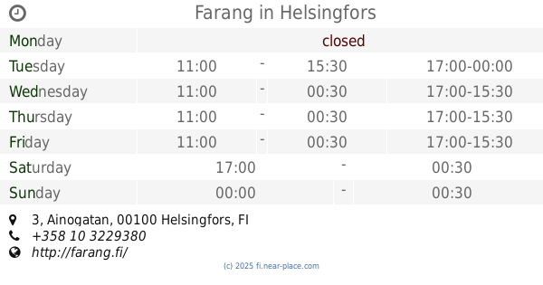
Farang
Ainogatan 3, Helsingfors
Cafe
read more
1.066 km
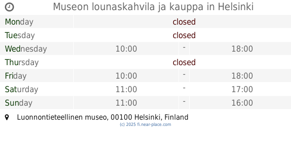
Museon lounaskahvila ja kauppa
Luonnontieteellinen museo, Helsinki
Cafe
read more
1.152 km
Cafe Sanomakahvila
Tölöviksgatan 2
Cafe
read more
1.208 km
Kiasma Café
Mannerheimplatsen 2, Helsingfors
Cafe
read more
1.251 km
FreshStop Eliel
Elielinaukio 5, Helsinki
Cafe
read more
📑
all categories
Accounting
Administrative area level 1
Administrative area level 2
Airport
Amusement park
Aquarium
Art gallery
Atm
Bakery
Bank
Bar
Beauty salon
Bicycle store
Book store
Bowling alley
Bus station
Cafe
Campground
Car dealer
Car rental
Car repair
Car wash
Casino
Cemetery
Church
City hall
Clothing store
Colloquial area
Convenience store
Courthouse
Dentist
Department store
Doctor
Electrician
Electronics store
Embassy
Establishment
Finance
Fire station
Florist
Food
Funeral home
Furniture store
Gas station
General contractor
Grocery or supermarket
Gym
Hair care
Hardware store
Health
Hindu Temple
Home goods store
Hospital
Insurance agency
Jewelry store
Laundry
Lawyer
Library
Light rail station
Liquor store
Local government office
Locality
Locksmith
Lodging
Meal delivery
Meal takeaway
Mosque
Movie rental
Movie theater
Moving company
Museum
Natural feature
Neighborhood
Night club
Painter
Park
Parking
Pet store
Pharmacy
Physiotherapist
Place of worship
Plumber
Point of interest
Police
Political
Post office
Premise
Real estate agency
Restaurant
Roofing contractor
Route
Rv park, camping
School
Shoe store
Shopping mall
Spa
Stadium
Storage
Store
Subpremise
Subway station
Supermarket
Synagogue
Taxi stand
Train station
Transit station
Travel agency
University
Veterinary care
Zoo
administrative area level 3
↑